GeoMorpher: A New Tool That Will Change Geology
Executive Summary
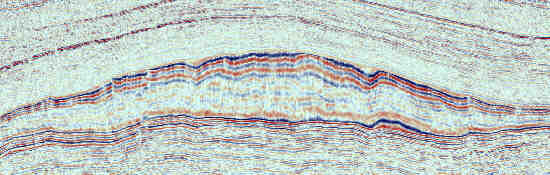
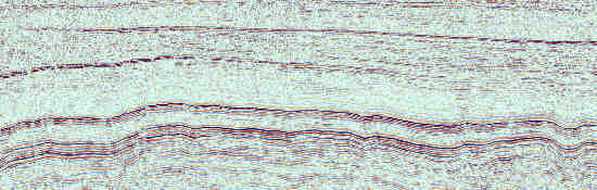
A new technique called GeoMorphing has been developed
for digital manipulation of geological images that will change the way
we use seismic and other data to understand geology and geophysics. Capable
of restoring any structural deformation including normal and reverse faulting
and folds, it allows the stratigraphic information to be seen through the
overprint of structural deformation. An article describing the technique
will appear in a forthcoming issue of "The Leading Edge".
Having developed the technique I am now able to offer it as a service
to interested parties. Simply email
me a screenshot of your data and guidelines for how you want it reconstructed,
and I will complete the job for you, with the first image often being available
on a 24 hr or even overnight basis, depending on which time zone you are
in (I'm in Australia which is overnight for UK and USA clients).
Contents:
Introduction
What is GeoMorphing?
How does GeoMorphing work?
An Example - Fault Reconstruction
What Else can we do with GeoMorphing?
Is GeoMorphing a Competitive advantage for Your
Company?
How do we maximise the advantages of Geomorphing?
Can I use GeoMorpher in my own office?
What are the Limitations of GeoMorpher?
Appendices:
Enhancing GeoMorpher to improve its geological functionality
Where did Morpher come from?
Tutorial
What's New on these pages?
For more information, contact Nick
Hoffman, We-Never-Sleep Geophysics, Melbourne, Australia


Compiled by Nick Hoffman,
"Geophysicist
Extraordinaire". Regular updates listed in "What's
New"
Acknowledgements:
Rob Cowley for showing the way with some fine
Intranet Pages.
Peter Chan for stopping talking while I wrote
down the original idea one day over coffee.